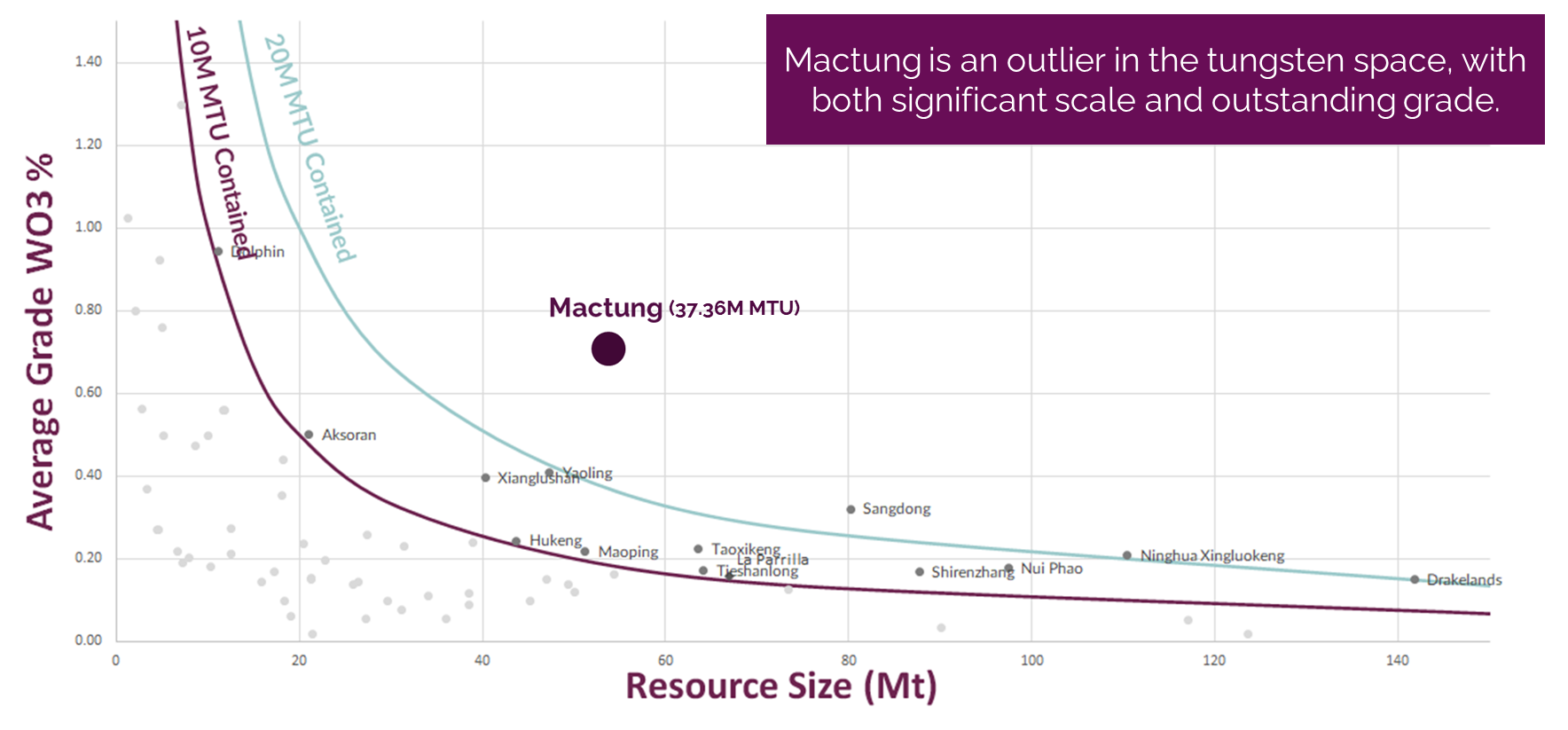
MACTUNG PROJECT - Tungsten
Mactung is one of the largest and highest-grade tungsten deposits in the world. It is an advanced stage project with extensive drilling, engineering, metallurgy, geotechnical, and environmental baseline data collected by previous owners that supported a Feasibility Study in 2009. Skarn mineralization is developed in carbonate rocks near the contact with a granite intrusion. Historic 2007 indicated resources1 totaled 33.0 million tonnes grading 0.88% WO3 (tungsten trioxide) plus historic inferred resources of 11.8 million tonnes grading 0.78% WO3. The 37.6 km2 property is located adjacent to Fireweed’s Macmillan Pass Property and accessed by the same road providing potential for future project synergies.

Location & History
The Mactung Property adjoins Fireweed’s Macmillan Pass Property and straddles the boundary between the Yukon and Northwest Territories . The Mactung tungsten deposit is located 13 km north of the Tom deposit (Figure 1). The Mactung Property can be reached by an access road that joins the North Canol Highway 230 km from Ross River, or by the government-maintained Macmillan Pass airstrip near the Tom deposit.
Mactung was discovered and staked in 1962 by an Amax geologist. Extensive drilling, metallurgical testing, and multiple historical resource estimates were completed over the next twenty years. The property changed ownership several times and was subsequently acquired by the North American Tungsten Corporation (NATC) in 1997. In 2007 NATC published updated mineral resources (see below) and in 2009 published a positive feasibility study (available at www.sedar.com under the NATC profile). The Yukon Environmental and Socio-economic Assessment Board issued a positive screening report for the Mactung Project in June 2014 and recommended it proceed to licensing without review, subject to terms and conditions, which were subsequently adopted and supplemented by the Yukon Government in its September 2014 Decision Document. However, in June 2015 NATC filed for and was granted creditor protection mainly related to operation of their Cantung mine located further south. The GNWT purchased the Mactung Project for $4.5 million in the fall of 2015, and subsequently obtained a Class 4 Mining Land Use Approval in 2020. Fireweed has now signed a binding LOI for acquisition of the Mactung Project with the GNWT (see details below).
Sustainability Context
Fireweed respectfully acknowledges that the Mactung Project is located within the traditional territories of the Kaska Dena and First Nation of Na-Cho Nyäk Dun, and the Sahtú Settlement Area. For the benefit of present and future generations, Fireweed will conduct mineral development activities in a sustainable manner by working collaboratively with Indigenous groups and local communities, establishing a respectful and safe working environment, achieving a high standard of environmental stewardship, and undertaking studies and implementing measures to address local interests and issues.
Mactung is a tungsten skarn deposit located on the eastern margin of the Selwyn basin in the Canadian Cordillera’s Tombstone-Tungsten Belt (TTB). The mid-Cretaceous TTB spans Alaska, Yukon, and NWT, and hosts many other significant mineral deposits. The Mactung deposit is associated with Tungsten suite intrusions that intruded late Precambrian to Palaeozoic, variably metamorphosed clastic and interbedded carbonate rocks of the Selwyn basin. The tungsten mineralization at Mactung is comprised mostly of scheelite (CaWO4) and is dominated by calcic mineral assemblages associated with abundant pyrrhotite that developed within permeable limestone units of the Cambrian-Ordovician host rocks. Although the previous feasibility study considered only underground development, the vast majority of tungsten mineralization at Mactung can be found within 200 m from surface.
Mactung Historic Drilling and Historic Estimates
Geological mapping and surface sample programs were conducted in the early and mid-1960’s, with drilling beginning in 1968. To date, approximately 38,000 m of drilling in 312 holes have been completed on the property, in addition to multiple historic resource estimates. An adit was opened in 1973 to enable underground exploration and bulk sampling; at least 1,200 metres of lateral underground development has occurred, including bulk samples of 270 tonnes in 1973, 3.5 tonnes in 1979, 650 tonnes in 1983, and 79 tonnes in 2005, enabling extensive metallurgical test work.
Cautionary and Background Statements regarding Historic Estimates
A 2007 Technical Report1 on the Mactung Tungsten Deposit prepared by Wardrop for the NATC reported an Indicated Mineral Resource of 33,029 kt grading 0.88% WO3 and an Inferred Mineral Resource of 11,857 kt grading 0.78% WO3. The following assumptions were made during the calculation of this historical Mineral Resource: 1.) CIM definitions (December 2005) were followed for the classification of the mineral resources, 2.) Kriging interpolation estimates were reported at a block cut-off of 0.5% WO3, which are based on assays capped at unique levels for each zone, 4.) Blocks were modeled as 10 m x 10 m, with a minimum vertical thickness of 4.5 m. Grades were diluted accordingly, if required, as modeled mineralized envelopes range in thickness from 1 m to over 50 m. Average thickness of the mineralized lenses is approximately 18 m, 5.) Tonnage was estimated by multiplying the block’s respective volume by the specific gravity (“SG”). The SG was based on densities established by an underground bulk sample taken from the 2B zone as well as data used in previous studies. Wardrop did not review any data or calculations related to the SG determination.
A 2009 Amended Technical Report2 on the Mactung Property produced by Wardrop for NATC reported a probable mineral reserve estimate of 10,790 kt grading 1.1869% WO3. The following assumptions were made during the calculation of this historical mineral reserve estimate: 1.) Mineral reserves reported follow the NI 43-101 definition of “the economically mineable part of a measured or Indicated Mineral Resource demonstrated by at least a Preliminary Feasibility Study”, 2.) A mining cut-off grade of 0.616% WO3 was calculated based on underground operating cost estimates obtained from Wardrop’s October 2007 Internal Economic Update, 3.) Calculation of the underground mineral reserves was limited in extent to mining the measured and indicated mineral resources located within the Yukon, 4.) A combination of Long-hole (LH) Stoping and Mechanized Cut-and-Fill (MCF) mining techniques will be used. LH stoping is the primary mining method and only regions where the mineralization is less than 12 m thick or dips steeply, will be mined with MCF, 5.) For the LH stoping method, reserves were calculated using a total recovery factor of 73.2% and 12% dilution, grading 0.1% WO3. For the MCF method, reserves were calculated at a total recovery factor of 83.5% and 9% dilution, grading 0.1% WO3, 6.) A 3-D block model was designed with 10 m x 10 m x 10 m blocks, using the following parameters: northing, easting and elevation coordinates, zone identification, resource category, WO3 percentage, and zone percentage (percentage of the block that lies within the zone), 7.) Probable mineral reserves were calculated by Wardrop using Gemcom SurpacTM Version 6.02 software.
The reader is cautioned that a qualified person has not done sufficient work to classify the historical estimates in this news release as current mineral resources or mineral reserves. The Company has not verified these historical resources and is not treating the historical estimates as current mineral resources or mineral reserves. While these estimates were prepared in accordance with National Instrument 43-101 and the “Canadian Institute of Mining, Metallurgy and Petroleum Standards on Mineral Resources and Mineral Reserves Definition Guidelines” in effect at the time, there is no assurance that they are in accordance with current standards and these resource estimates should not be regarded as consistent with current standards or unduly relied upon as such. Fireweed includes these historical estimates in this news release for information purposes as they represent relevant material historical data which have previously been publicly disclosed and are accessible online. To the Company’s knowledge, the 2007 technical report is the most recent mineral resource estimate available for the Mactung deposits and the 2009 preliminary economic study is the most recent economic study. Further and updated work is needed to validate the drill hole database, associated assay results, economics and other pertinent information. Fireweed plans to prepare updated NI 43-101 compliant mineral resource estimate and preliminary economic studies and reports for the Mactung deposits in the coming year.